CLICK HERE for Silver City & CMI project areas: This is a Google map. Click on the “Satellite” icon, then click on “Earth” to get a tilted satellite view. You can fly around in the scene using the arrows on the big buttons on the left. The upper one tilts and rotates, the lower one moves horizontally. You’ll see how the terrain reflects noise into the town from the drilling/possible mine area. You can also see how the CMI mill & heap leach facility is already filling a large proportion of American Flat, the headwaters of American Creek, a tributary to the Carson River!! Click on “Satellite” again, then click on “Terrain” for a shaded relief map.


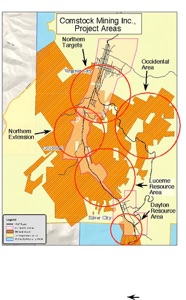
The first four maps below show the National Landmark (blue) , the Historic District (yellow), townships (red outline) and CMI holdings (orange). The 5th map shows the type of CMI holdings. Play the slide show to view maps at larger scale. Or double click to enlarge and enable download.
Carson River Mercury Superfund Site Maps: Click on this link to go to Nevada Dept. of Environmental Protection site with superfund maps and reports for download. No need to say much about these maps!
